|
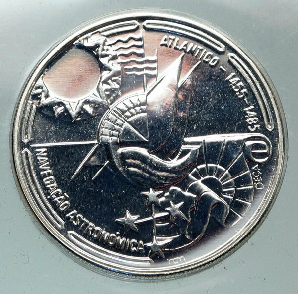
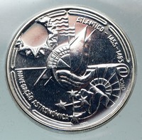
Portugal – Golden Age of Portugese Discoveries – Astronomic Navigation
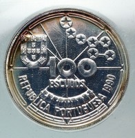
1990 Proof Silver 100 Escudos 34mm (21.00 grams) 0.925 Silver (0.6245 oz. ASW)
Reference: KM# 649a
100 ESCUDOS REPUBLICA PORTUGUESA, Shield within circle.
ATLANTICO – 1455-1485 NAVEGAÇÃO ASTRONÓMICA D’EÇA, Artistic designs of celestial navigation.
You are bidding on the exact item pictured, provided with a Certificate of Authenticity and Lifetime Guarantee of Authenticity.
 Celestial navigation, also known as astronavigation, is the ancient and modern practice of position fixing that enables a navigator to transition through a space without having to rely on estimated calculations, or dead reckoning, to know their position. Celestial navigation uses ‘sights’, or angular measurements taken between a celestial body (e.g. the Sun, the Moon, a planet, or a star) and the visible horizon. The Sun is most commonly used, but navigators can also use the Moon, a planet, Polaris, or one of 57 other navigational stars whose coordinates are tabulated in the nautical almanac and air almanacs. Celestial navigation, also known as astronavigation, is the ancient and modern practice of position fixing that enables a navigator to transition through a space without having to rely on estimated calculations, or dead reckoning, to know their position. Celestial navigation uses ‘sights’, or angular measurements taken between a celestial body (e.g. the Sun, the Moon, a planet, or a star) and the visible horizon. The Sun is most commonly used, but navigators can also use the Moon, a planet, Polaris, or one of 57 other navigational stars whose coordinates are tabulated in the nautical almanac and air almanacs.
Celestial navigation is the use of angular measurements (sights) between celestial bodies and the visible horizon to locate one’s position in the world, on land as well as at sea. At a given time, any celestial body is located directly over one point on the Earth’s surface. The latitude and longitude of that point is known as the celestial body’s geographic position (GP), the location of which can be determined from tables in the nautical or air almanac for that year. The measured angle between the celestial body and the visible horizon is directly related to the distance between the celestial body’s GP and the observer’s position. After some computations, referred to as sight reduction, this measurement is used to plot a line of position (LOP) on a navigational chart or plotting worksheet, the observer’s position being somewhere on that line. (The LOP is actually a short segment of a very large circle on Earth that surrounds the GP of the observed celestial body. An observer located anywhere on the circumference of this circle on Earth, measuring the angle of the same celestial body above the horizon at that instant of time, would observe that body to be at the same angle above the horizon.) Sights on two celestial bodies give two such lines on the chart, intersecting at the observer’s position (actually, the two circles would result in two points of intersection arising from sights on two stars described above, but one can be discarded since it will be far from the estimated position-see the figure at example below). Most navigators will use sights of three to five stars, if available, since that will result in only one common intersection and minimizes the chance of error. That premise is the basis for the most commonly used method of celestial navigation, referred to as the ‘altitude-intercept method’. At least three points must be plotted. The plot intersection will usually provide a triangle where the exact position is inside of it. Accuracy of the sights is indicated by the size of the triangle.
There are several other methods of celestial navigation that will also provide position-finding using sextant observations, such as the noon sight, and the more archaic lunar distance method. Joshua Slocum used the lunar distance method during the first recorded single-handed circumnavigation of the world. Unlike the altitude-intercept method, the noon sight and lunar distance methods do not require accurate knowledge of time. The altitude-intercept method of celestial navigation requires that the observer know exact Greenwich Mean Time (GMT) at the moment of their observation of the celestial body, to the second-since for every four seconds that the time source (commonly a chronometer or, in aircraft, an accurate ‘hack watch’) is in error, the position will be off by approximately one nautical mile.
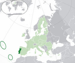  Portugal, officially the Portuguese Republic (Portuguese: República Portuguesa), is a country on the Iberian Peninsula, in Southwestern Europe. It is the westernmost country of mainland Europe, being bordered by the Atlantic Ocean to the west and south and by Spain to the north and east. The Portugal-Spain border is 1,214 km (754 mi) long and considered the longest uninterrupted border within the European Union. The republic also includes the Atlantic archipelagos of the Azores and Madeira, both autonomous regions with their own regional governments. Portugal, officially the Portuguese Republic (Portuguese: República Portuguesa), is a country on the Iberian Peninsula, in Southwestern Europe. It is the westernmost country of mainland Europe, being bordered by the Atlantic Ocean to the west and south and by Spain to the north and east. The Portugal-Spain border is 1,214 km (754 mi) long and considered the longest uninterrupted border within the European Union. The republic also includes the Atlantic archipelagos of the Azores and Madeira, both autonomous regions with their own regional governments.
 The territory of modern Portugal has been continuously settled, invaded and fought over since prehistoric times. The Pre-Celts, Celts, Phoenicians, Carthaginians and the Romans were followed by the invasions of the Visigothic and the Suebi Germanic peoples, who were themselves later invaded by the Moors. These Muslim peoples were eventually expelled during the Christian Reconquista. Portuguese nationality can be traced back to the creation of the First County of Portugal, in 868. In 1139, Afonso Henriques was proclaimed King of Portugal, thus firmly establishing Portuguese independence, under the Portuguese House of Burgundy. The territory of modern Portugal has been continuously settled, invaded and fought over since prehistoric times. The Pre-Celts, Celts, Phoenicians, Carthaginians and the Romans were followed by the invasions of the Visigothic and the Suebi Germanic peoples, who were themselves later invaded by the Moors. These Muslim peoples were eventually expelled during the Christian Reconquista. Portuguese nationality can be traced back to the creation of the First County of Portugal, in 868. In 1139, Afonso Henriques was proclaimed King of Portugal, thus firmly establishing Portuguese independence, under the Portuguese House of Burgundy.
In the 15th and 16th centuries, under the House of Aviz, which took power following the 1383-85 Crisis, Portugal expanded Western influence and established the first global empire, becoming one of the world’s major economic, political and military powers. During this time, Portuguese explorers pioneered maritime exploration in the Age of Discovery, notably under royal patronage of Prince Henry the Navigator and King João II, with such notable discoveries as Vasco da Gama’s sea route to India (1497-98), Pedro Álvares Cabral’s discovery of Brazil (1500), and Bartolomeu Dias’s reaching of the Cape of Good Hope. Portugal monopolized the spice trade during this time, under royal command of the Casa da Índia, and the Portuguese Empire expanded with military campaigns led in Asia, notably under Afonso de Albuquerque, who was known as the ‘Caesar of the East’.
The destruction of Lisbon in a 1755 earthquake, the country’s occupation during the Napoleonic Wars, the independence of Brazil (1822), and the Liberal Wars (1828-1834), all left Portugal crippled from war and diminished in its world power. After the 1910 revolution deposed the monarchy, the democratic but unstable Portuguese First Republic was established, later being superseded by the ‘Estado Novo’ right-wing authoritarian regime. Democracy was restored after the Portuguese Colonial War and the Carnation Revolution in 1974. Shortly after, independence was granted to all its colonies and East Timor, with the exception of Macau, which was handed over to China in 1999. This marked the end of the longest-lived European colonial empire, leaving a profound cultural and architectural influence across the globe and a legacy of over 250 million Portuguese speakers today.
Portugal is a developed country with a high-income advanced economy and high living standards. It is the 5th most peaceful country in the world, maintaining a unitary semi-presidential republican form of government. It has the 18th highest Social Progress in the world, putting it ahead of other Western European countries like France, Spain and Italy. It is a member of numerous international organizations, including the United Nations, the European Union, the eurozone, OECD, NATO and the Community of Portuguese Language Countries. Portugal is also known for having decriminalized the usage of all common drugs in 2001, the first country in the world to do so. However, the sale and distribution of these drugs is still illegal in Portugal.
|

 Celestial navigation, also known as astronavigation, is the ancient and modern practice of position fixing that enables a navigator to transition through a space without having to rely on estimated calculations, or dead reckoning, to know their position. Celestial navigation uses ‘sights’, or angular measurements taken between a celestial body (e.g. the Sun, the Moon, a planet, or a star) and the visible horizon. The Sun is most commonly used, but navigators can also use the Moon, a planet, Polaris, or one of 57 other navigational stars whose coordinates are tabulated in the nautical almanac and air almanacs.
 Portugal, officially the Portuguese Republic (Portuguese: República Portuguesa), is a country on the Iberian Peninsula, in Southwestern Europe. It is the westernmost country of mainland Europe, being bordered by the Atlantic Ocean to the west and south and by Spain to the north and east. The Portugal-Spain border is 1,214 km (754 mi) long and considered the longest uninterrupted border within the European Union. The republic also includes the Atlantic archipelagos of the Azores and Madeira, both autonomous regions with their own regional governments.
 The territory of modern Portugal has been continuously settled, invaded and fought over since prehistoric times. The Pre-Celts, Celts, Phoenicians, Carthaginians and the Romans were followed by the invasions of the Visigothic and the Suebi Germanic peoples, who were themselves later invaded by the Moors. These Muslim peoples were eventually expelled during the Christian Reconquista. Portuguese nationality can be traced back to the creation of the First County of Portugal, in 868. In 1139, Afonso Henriques was proclaimed King of Portugal, thus firmly establishing Portuguese independence, under the Portuguese House of Burgundy.

